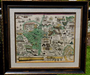
Rare illustration of 18th century siege warfare, fortifications and weaponry by Johann Homann
CC-0281 – Rare illustration of 18th century siege warfare, fortifications and weaponry
Cartographer: Johann Baptist Homann
Published: Approximately 1720
Map dimensions: Approx. 24-1/2″ W x 21″ H
Frame Dimensions: 32-1/4″ W x 28-3/4″ H
Condition: Preservation is overall good. Paper shows typical signs of age, a small tear at the bottom center, which is barely visible and paper has a few small stains. Coloring is original and in good condition. Overall nice eye appeal and good condition.
Description: This amazing illustration contains dozens of diagrams and plans that outline construction of fortifications, embattlements, personal armaments, war machines, and all sorts of unusual weaponry. During this period, the design of a fortification was of great importance and often determined whether a battle was won or lost. Viewed from above the ground, the fortification plan resembled a star which was made up of a series of geometrically interrelated planes, the idea being to cover all the projecting parts of the fortifications by an effective crossfire. (Christopher Duffy – Fire and Stone). In short, there was to be no place for attackers to find shelter from the defenders’ cannon and musket fire as they approached the fort.
In addition to the weapons and fortifications used on land, the upper left portion of the illustration also includes a variety of ships and barges that would have been used during a siege.
The approximate translation of the title text reads:
“Table showing all the items belonging to the art of war. Fortress construction and artillery, to siege and sites of fortifications and castles in field battles. Army camps and camp sites, also all ship and sea materials are presented, edited by Johann Baptista Homann.”
In stock
$4,250.00